The world is big when you fight against it. We move with it.. it is small for us.
-- Anon
The alarm went off at 5am, and I sat up, wondering where I was. I seldom experience the sense of dislocation that many riders in multi-day rides or rallies experience; I usually save the “waking up confused and wondering why your bedroom looks so different” for after the rally. I felt rested and ready, and headed across the street to pull a receipt from the gas station across the street to mark the end of my rest bonus. I was about 10 minutes short of a full 8 hours, so I waited, sitting on the sidewalk in the pre-dawn gloom, eating some breakfast and doing some routing with Google. A 2-up couple pulled in to get gas. We exchanged waves, but little else; I’d see them tonight in Tulsa, God willing and the creek don’t rise.
23) REST1 - 2,880 pts
21:26-05:27 EDT
Earn six (6) points per minute for staying in one place for a minimum of 4 hours, up to 8 hours maximum credit. Your starting receipt may be on Monday but you must then document at least 4 hours on Tuesday (no points are earned before 12:00:01 AM on Tuesday.)
| This segment: | 108 miles, 9h29m |
| Total: | 1,615 miles, 43h27m |
| Time Remaining: | 17h33m |
| Points scored: | 14,674 |
I suppose this is as good a place as any to drop a quick note about how I generate these reports, or at least the statistics for mileage, time, and score.
Mileage
For most rallies I’m not keeping strict track of mileage, nor looking at my odo at each stop. Some rallies require this as part of the paperwork for scoring, but since this rally uses electronic submission, such record keeping isn’t required. Starting with HoT this year, I started photographing my odometer (and clock) at each stop, but in general I’m generating the mileage by looking at the Google Maps estimate based on the embedded map shown in each bonus I list here. This is a bit inaccurate at times, and the actual number of miles day-to-day may differ from this. This is often caused by my not accounting for any mileage incurred by gas stops or rest areas, or for the natural drift between a motorcycle’s odometer and reality.
Time
I use the electronic timestamp on the photo I submitted to scoring, as well as my satellite track in Spotwalla to calculate the time between 2 bonuses, as that will also account for stops, traffic, potty breaks, performance awards, etc along the way. This is why you’ll often see it taking longer in the stats box than what the Google Maps embed claims. I do the time elapsed and time remaining semi-manually, sometimes using a time calculator, sometimes in my head. Regardless, I sometimes mess up doing the math in time.
During the rally, I left my motorcycle’s clock set to “rally time” – that is, the time at the finish line in Pittsburgh (EDT.) Additionally, I used EDT for every entry on my scoresheet submitted to the scorers at each checkpoint; it keeps the math simple, and I’m less likely to make routing mistakes based on thinking I have an hour one way or the other.
Score
I’m keeping a running tally at each bonus location that includes the points I am claiming from bonuses, as well as combos as I score them. Rest bonuses are also included, but not any non-riding bonuses (such as we might earn for getting our pre-rally paperwork done on time, or having our location tracker registered with Spotwalla correctly) are not included. You might see a difference between the running tally and my final credited score for a given leg; this is likely due to one of these non-riding bonuses (or penalties..) or I’ve made a math mistake somewhere. Don’t worry, it all comes right in the end. I promise.
I had originally intended my next bonus to be ARDA, a fried catfish joint in a building made up to look like a riverboat. I was looking at a tight time window to get to the relatively valuable (>1,600 points) for the group photo bonus, and ARDA, at 165, seemed like an easy bonus to bypass. Garmin was showing me that I could gain back 45 minutes if I dropped it.. and besides, it was dark, and I’d already heard word about Lisa Rufo and daughter Molly hitting a deer and going down, as well as Gerry Arel having what was rumored to be a run-in with construction debris in the same rainstorm as I was in the night before, and it spooked me a little. I already had secured enough points to stay on track for finisher status, and in the grand scheme of things 165 points doesn’t matter unless you’re shooting for a competitive slot. A 45 minute detour through rural Arkansas for 165 points I didn’t need? It was an easy call.
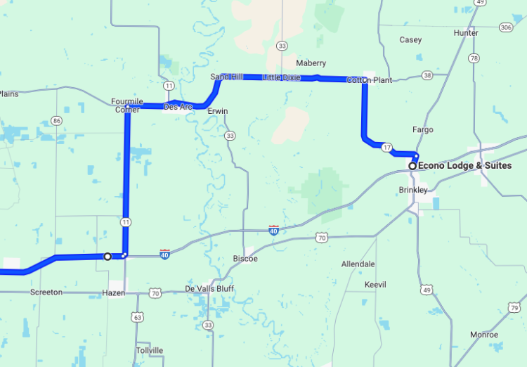
Of course, later on in the comfort of home, I would double check this routing, and found that it only would've added 15 minutes. If I'd know that at the time, I wouldn't have passed it up.. but would that have been the right move?
Riding through the pre-dawn along I-40, I saw a highway maintenance crew cleaning up the roadkill. They had a heavy-duty truck with what looks a lot like a bucket loader attachment on the front, except instead of a bucket it had a large shelf or panel that they sort of slide under the body of the deer – sort of like a pizza peel but for carrion. I didn’t get a look in the back as I passed, but I imagine it was full of other casualties. The fact that they have specialized equipment for dealing with dead deer should give one pause; in fact, shortly after passing the truck, I start seeing roadkill every few miles. I passed the time by counting deer carcasses, and felt better about my choice to stick to the highway with each one passed.
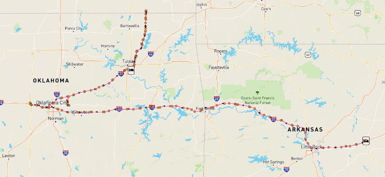
I-40 skirts around the north edge of Little Rock, following the Arkansas River along it’s northern bank. It runs mostly through farmland, the foothills of the Boston Mountains to my right, framed most of the way by a curtain of trees on either side of the highway and the median, giving the road the feeling of remote wildness, a green tunnel through the Ozarks. I stopped at a rest area about 25 minutes east of Fort Smith, AR and the Oklahoma border, and had a protein bar and mixed up a bottle of electrolytes, the sun already starting to threaten a hot day ahead of me, casting a menacing orange glare. I wondered if there were fires or pollution nearby causing the discoloration, while moms and children clambered out of SUVs, giving me stink eye and judging my road-worn appearance. I smiled and sighed at the same time; smiling because oh lady, wait till you see me in another 5 or 6 days, and sighed because it’s always the same… but if you don’t let people disappoint you, you’re never going to be ready to let them surprise you, either.
Eastern Oklahoma was a bit of a revelation. Having done next to zero travel through this part of the state, I didn’t realize how beautiful it was. The deep forest of the Ozarks giving way to patchy copses of trees, gently rolling hills of grass as woods and prairie disagree about where one ends and the other begins. It reminded me of parts of Texas, and with good reason – this is part of the “Cross Timbers” region, and was a significant challenge for early settlers to blaze a trail through, a thick, dense woodland marking the edge of the Great Plains.
I was keeping an eye on the weather, and when I stopped in Checotah, OK for gas, I spotted some danger on the horizon; a fast-moving derecho was forming west of Wichita, and was sweeping southeast at a ridiculously fast pace, straight at Tulsa. My route had me heading to the west of Oklahoma City, then doubling back east to Tulsa and then north into Kansas. I was going to have to keep an eye on this one; I might sneak in behind it, or get out ahead of it to Tulsa.. or even head north first THEN cut east behind the storm. I’d have to make that call as I was leaving the next bonus.
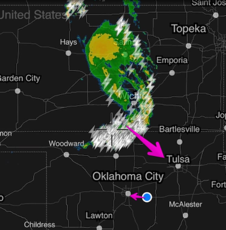
About an hour later, this is how the map looked...
When new rally riders ask me about what sets the big multi-day rallies like the IBR or LDX apart, it’s that there’s times when your bonuses might be hundreds of miles apart, and today was a good example of this. Besides a stop for gas and a couple rest area breaks, nothing broke the routine for more than 400 miles. I-40 a long, straight ribbon of concrete and asphalt, and the weather, sunny and warm most of the day, was starting to cloud up to the north as I passed through OKC to a small town on the eastern suburb of El Reno, OK. A handful of miles before exiting I-40, I yet again found myself riding behind Danny Dossman, and we both arrived at Sid’s Diner, home of the Fried Onion Burger Day Festival.
24) OKER - Fried Onion Burger Day Festival (Sid’s Diner) - El Reno, OK - 702 pts
11:13 EDT
Take a photo of Sid’s Diner with the “Onion Burger” text on the façade clearly visible.
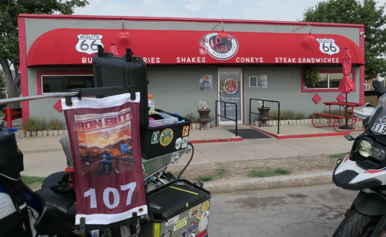
Apparently, Sid’s had redone it’s fading awning since this bonus was scouted, and the new façade did NOT contain the phrase “Onion Burger” anywhere to be seen. Danny and I walked around the building twice, unable to find even a mention of this fabled delicacy. I called Jeff Earls for a quick clarification, and he advised us to just take as many photos as we deemed necessary to document we were in the correct location, so I snapped pics of each side of the building, a menu, and even my GPS screen showing my lat/long, and after looking at the weather, I headed back out to the highway, passing a pair of riders heading in to the bonus as I did.
| This segment: | 423 miles, 5h46m |
| Total: | 2,038 miles, 49h13m |
| Time Remaining: | 11h47m |
| Points scored: | 15,376 |
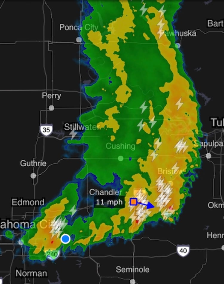
Leaving the bonus, the weather radar looked good, and I thought I could slip in behind the storm front as it passed south across I-44. However, the storm had other ideas; as I crossed through OKC in record time, it chose to slow down, and I soon found myself getting tossed around by wind, some of the blackest clouds I’ve ever seen just to my left, blue skies to the right. I wondered how far I could reasonably get before needing to take shelter, and a scan through the maps showed me there was almost nothing between OKC (which I’d just left) and Tulsa, and as the wind really decided to shove me around, I watched lightning bolts splashing left and right across the northern horizon, marching close and closer. I needed to find shelter, and fast.
An exit came up, and seeing a helpful “NEXT EXIT 30 MILES” sign, decided to err on the side of safety and burn into the nearly 90 minutes of buffer time that I had and get under cover of something. I headed south on the Kickapoo Turnpike, and as soon as I did, the angry wind just stopped – I was moving with the storm now, ahead of me nothing but blue skies and stillness, but in my mirrors nothing but terrible, roiling darkness.
5 miles to the first exit - nothing! It’s all grass and farms. 5 more miles, the storm wasn’t gaining on me, but I was burning miles.. this exit for sure! I spotted signs of life, and squeaked off the turnpike into the small town of Harrah, OK, pulling into the first fast food place I saw, a “Taco Mayo” (an apt name, judging by the menu and the clientele..) As soon as I stopped, I felt the full force of the wind gusting around, sending grass clippings and detritus from the fields skittering across the pavement. I grabbed my rally paperwork and camera and ran inside just as the first fat drops of rains started smashing down.
One of those modern, hip taco places - you know the ones, with the corrugated metal used for roofing as walls, fast-food aesthetics but with a surprising “fusion” menu, a TV mounted high in one corner was tuned in to some sports event, perched between a parrot piñata and a hanging Corona beer sign. I claimed a booth, and knowing I’d be here for a bit, put in an order, then watched the storm break through the window. The first bass drum crashes of thunder shook the windows, and one of the girls working the counter turned the TV to a local news weather report - big damage in Tulsa, a crawl of counties and towns under extreme storm warnings crawled through the chyron. The kitchen staff, seemingly with nothing else to do despite it being lunch time, emerged from the back to stare out at the wall of wind-whipped water… again, when the locals are impressed by the weather, you know it’s something else.
I almost timed it right!
I hunkered down and tried not watch the clock; instead, I went over my paperwork, checked that all my photos were in place, and caught up on rally news. It looked like Lisa, Molly, and Gerry were all OK, but that for them, the rally was over. I also saw a rather shocking bit of news that someone had posted info about the group photo bonus to the FJR forums, and someone else had posted a photo of a page of the rally book to Facebook - what on earth were they thinking?! You may or may not agree with the “no social media” policy, but there a difference between saying “happy birthday” to a dear friend and posting where and when you can find rally riders. It’s the very REASON for the policy, explicitly and meticulously explained to us, so there’s no plea of ignorance possible… how do you break that rule?!
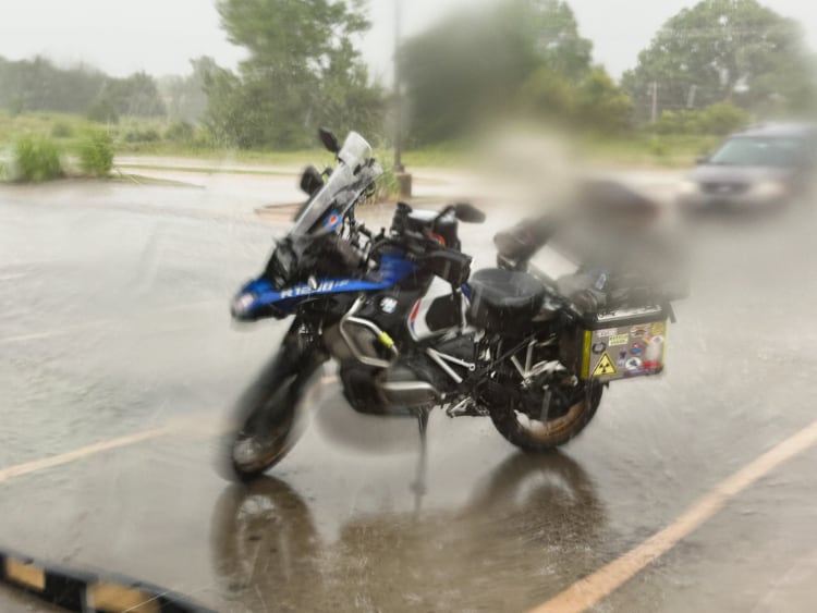
At least my bike (and laundry strapped onto the panniers!) got a good wash..
Slowly, inexorably, the storm passed overhead, having eaten up nearly all my buffer time. When the radar showed that the worst of it had passed, and with no backside lightning to contend with, I got back on the bike and got the wheels moving. I had maybe 15 minutes of slack time remaining to get to the group photo bonus, but the sun soon came out, and I made good time zipping northeast towards Tulsa on I-44; I even picked up a few minutes, buzzing along.. but as I got closer and closer to Tulsa, the wind started picking up again as I caught up to a band of the storm that was marching slowly west.
I needed a bio break anyways, so I pulled into a QuikTrip on the western side of Tulsa. I had to be at the group photo location in Coffeyville, KS at 16:00 exactly, and my current ETA was showing as 15:42 - I had time, but I needed to keep moving. When I came back out to the bike, the wind was swaying the tall signs advertising services to the highway, and a sideways rain started, swirling dust and stinging drops of needle-cold rain around. I glanced at the radar, saw another blob of yellow and red sliding slowly across Tulsa; no lightning, at least, but if I kept going I was going to be in it for sure. Watching the block, I gassed up, while one particularly strong gust rocked the bike, noticeably shifting it up and taking weight off the side stand - yikes! I blinked back dust, sheltered somewhat by the gas pump, and decided to give this part of the storm time to slip east and out of my path, watching the ETA to the next bonus click up..
15:50… 15:52… 15:55.. yikes!
Realizing it wasn’t going to get any better, I steeled my nerves and got back on the highway, blinking back a mote of dust that found its way into my helmet as I accelerated up the ramp. I merged gingerly, rain pelting down, and soon found myself crossing the Arkansas River south of downtown Tulsa in a wind-driven downpour on one of the worst-maintained stretches of interstate I’ve ever been on. Going 40mph with my blinkers on, visibility dreadful, I hit pothole after pothole, hammer blows of cold rainwater smashing into my legs with each puddle I plunged into. Big trucks blew by, giving a moment of relief from the wind only to pay it back in spades with a blast of turbulence and muddy, oily spray misting across my visor.. truly miserable.
15:56… 15:58…
The miserable conditions almost caused me to miss my exit, but luckily I was already in the right-most lane and slipped onto the exit at the last second, twisting around an under-construction cloverleaf onto US-169 north. The rain and wind started to settled down, but the road here was 1 narrow lane between Jersey barriers, and I was still losing time.
15:59… 16:02 …16:05
I was going to have to hustle and hope some combination of making up time and Garmin/Waze inaccuracies would work in my favor. Luckily for me, US-169 soon burst clear of the suburbs, right about the same time the rain and wind faded to nothing and a weak, patchy sunshine broke out. The next hour was a familiar pattern - fast roads with high speed limits, every 8-9 miles having to slow to a crawl through a small town. My radar detector chirped as I passed through each rural hamlet, and I saw multiple police parked along the main road through town, just waiting for someone in a hurry… someone like me. I was able to make up time despite these intermittent speed bumps of civilization.
16:04… 16:03….
One particularly large town, I got stuck behind someone going 15 in the 25 through town.. then 30 in the 40… and 35 in the 50! The first moment I had a clear view ahead, I zipped around them, just trying to keep the clock rolling down.
16:02… 16:01…
A white motorcycle pulled up fast and tight behind me, and I gulped - did I not notice a motorcycle patrol cop through one of the towns? Was I pinched? Nope - just another rally rider. As I slowed and pulled right, assuming they were law enforcement who wanted to discuss the finer points of Oklahoma law with me, they cracked it open and zipped right past me. I laughed and drafted behind them, as there was no other place they’d be going in this area, at this point in the rally, and certainly not with this amount of speed!
16:00… 15:59… we were both going to make it!
25) KSCO - ICEE Machine (Omar Knedlik) - Coffeyville, KS - 1,632 pts
16:00 EDT
Have your photo taken by IBR staff as part of a group in front of the Coffeyville mural on the west side of the building. Reminder: You must sign in with IBR staff on location prior to 1500 (local) time on June 21, 2023.
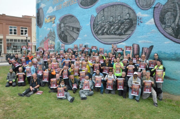
I pulled into the packed parking lot at 15:57, and ran to get signed in with rally staff. Nearly 70 of us squeezed together under the mural celebrating the creator of the ICEE machine, and then scattered.
| This segment: | 229 miles, 4h47m |
| Total: | 2,267 miles, 54h00m |
| Time Remaining: | 7h00m |
| Points scored: | 17,008 |
At this point, all pressure for the leg was off. It was around an hour and a half to the checkpoint hotel, and about 5 hours until we reached penalty time, so I took my sweet time packing up the bike. I took a few minutes to sort the packing on the bike, gathering up random fast food wrappers, tightening straps, etc, chatting with a few folks who were similarly taking their time. Leaving town, I slow poked back south on US-169. On the north edge of Tulsa, I spotted a Whataburger, so pulled off to claim another Gut Bomb Bingo bonus.
26) O1 - Whataburger - Owasso, OK - 248 pts
17:28 EDT
Get a receipt from any approved Whataburger location and take a photo of the same restaurant with your motorcycle in the photo.
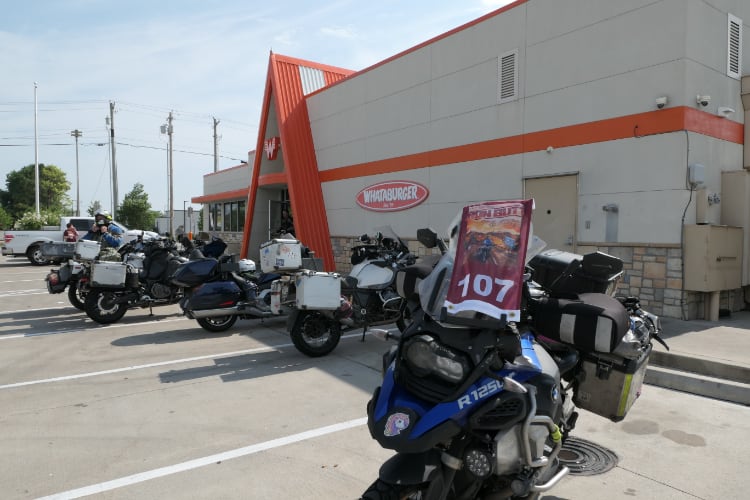
3 other bikes were in the parking lot, and more rally riders would come and go while sucked down a chocolate malt and chatted with other ralliers in the A/C.
| This segment: | 57 miles, 1h28m |
| Total: | 2,324 miles, 55h28m |
| Time Remaining: | 5h32m |
| Points scored: | 17,256 |
From here it was an easy run to the checkpoint hotel, only about 18 miles or so to the south side of Tulsa.
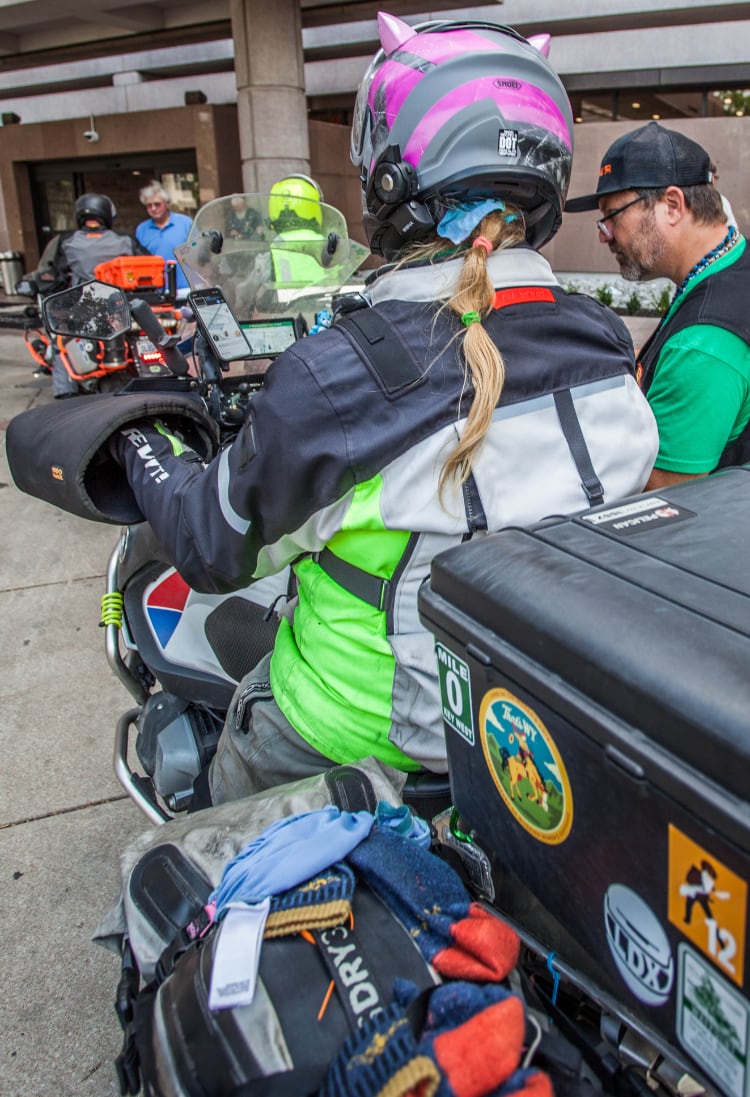
Getting my odometer reading confirmed by Chris Hopper
(Photo credit: Tobie Stevens)
I got myself signed in with Bill Thweat, officially stopping my rally close and starting a new one – I had an hour to present myself for scoring. What I should’ve done is used 10 minutes of that hour to get myself checked into the hotel, but instead I sat in the lobby and finalized my paperwork, which only took 20 minutes (if that) and then signed in for scoring. There was a huge backlog of riders who were in line ahead of me, pretty much everyone who was at the group photo a couple hours before. We all sat on the floor in the hallway outside the basement conference rooms, waiting for our number to be called. You could tell the rally vets at this point, who had used the hour between sign-in and scoring to get their rooms and change into street clothes, some of them taking advantage already of the dinner buffet that was available in the next conference room.
I sat and waited, finally starting to relax, but too worried about missing my number being called to go fetch dinner; there were vague threats of “consequences” if you weren’t immediately available when they called you! I really wanted to have an actual meal, go check in to my room, and take a shower.. but wait I did. Eventually though, I got pulled into scoring, where I surrendered the SD card from my camera, and then was assigned to a scorer – Chris Sakala – to go over the photos, receipts, and any other items I might needed to have brought to the table. I received a single 10-point penalty for a small error I made in writing down the code for a bonus on my claim sheet (I wrote “CALL” instead of “CALL1”…) but otherwise it was a smooth, painless process.
Released, I wandered over to the dinner hall, dropped all my gear on the floor, and tucked in to a plate, chit-chatting a little bit with folks, but I really wanted that shower, so I went and stood in line waiting for the front desk to sort out my reservation. Keys in hand, I soon found myself on the 7th floor on the complete opposite side of the large, sprawling hotel from the parking garage; that would be fun in the morning.. but that’s a problem for Tomorrow Kerri. Today Kerri needs a shower and to get her jammies on because she has to be downstairs for the mandatory rider meeting at 4am!
Day 3: 7,452 points -- 729 miles
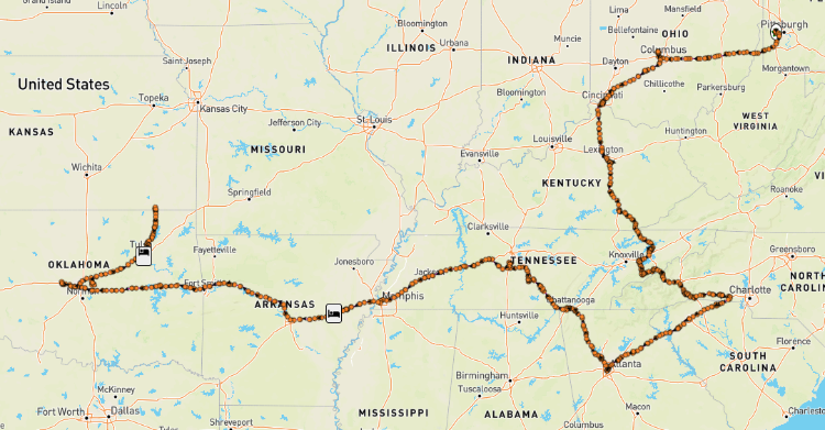
Leg One Total: 18,246 points -- 2,344 miles